The Whole Freakin' Area:
Things to Explain:
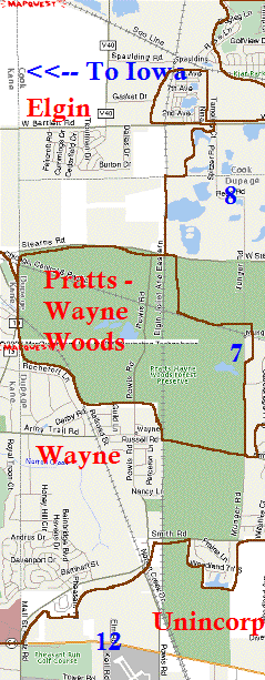
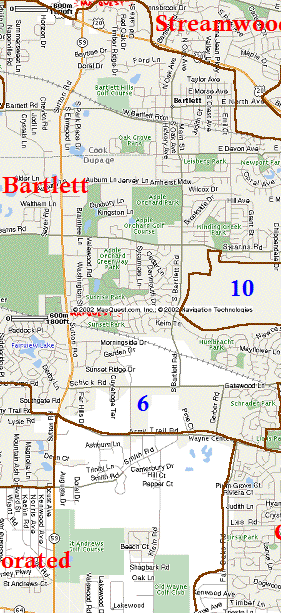
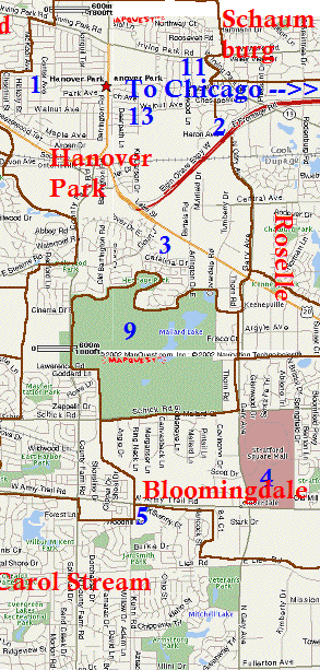
The brownish/orange lines that are all around are the boundary lines for the different Suburbs. The names of the different burbs are in red. The blue numbers corrospond to different things around the area. Read the details below, and then to see more click on either the #7 or on "Hanover Park".
Numbered Areas:
1: My neighborhood (Northwestern Section of Hanover Park)
2: Elgin O'Hare Expressway (That goes neither to Elgin or O'Hare)
3: The Black Hole: DENNY'S!
4: Stratford Square Mall (about 1/5 the size of Woodfield Mall, which is off the map)
5: Kuhn Road & Army Trail Road. This is where Sarah and I "found" the NO LEFT TURN sign, and where Willer and I "found" the ROAD CLOSED sign.
6: Bartlett High School. (BHS)
7. Munger Road. This is one hell of a road, let me tell you. Not only have i been pulled over 2 times on it, but it has a huge urban legend tied to it. Click here to read more about that!
8. Spitzer Road. North of Munger, Sptizer is located in what looks like a toxic waste dump. Bartlett wants to put a Nuclear Power Plant here. Click here to read more about that!
9. Mallard Lake Foreset Preserve. Home of the Mallard Lake Landfill (aka Mount Trashmore). On a good warm day, when the winds are from the south, i can smell it at my house.
10. Western edge of the Mallard Lake Forest Preserve. There's a pet cemetary located here.
11. Where Handy Andy used to be. It's located in the northeast corner of Hanover Park. It's technically located in HP, so when they tore it down, HP forgot to pick it up! Click here to read about that!
12. DuPage Airport. Go until you can go no more, and turn left. It is a given weird fact that if you follow this rule, chances are you will end up here. We did....several times.
13. Hanover Park Water Reclamation Plant. aka SEWAGE PLANT. On any given summer (or Fall or Spring) day, when the winds are from the east (Thank God that doesn't happen to often) you can smell that stench for MILES.
Click on Hanover Park to see a more detailed view of my actual neighborhood! Click on #7 or #8 to see read about Munger Road and the Urban Legend behind it.
More Odds and Ends:
The section labeled "Unincorporated" is really just an empty land with some golf clubs in it and the DuPage Airport. The few streets that people do live on, i'm assuming live in either Wayne or Carol Stream. .
Notice how Hanover Park extends rather far south along County Farm Road. It squeezes inbetween the east and western edges of the Mallard Lake Forest Preserve. The south side of Hanover Park is a little more richier than the North side (contrary to Chicago). The northwest side (where i live) is most likely the crappiest part of Hanover Park, what with the gangs and all. Very low income multilevel apartment buildings are here. The northeast side isn't too bad....still some gangs and shootings (a LOT of theft too), but the housing is a little more higher income but it's next to the sewage plant. And then the central part of HP, near the Elgin O'Hare Expressway is a combonation of both sides: crime and middle class housing.
Bartlett might LOOK bigger than Hanover Park, but HP has more residents. Bartlett has a lot of just open land and forest preserves and parks. Hanover Park crams those people in tight!
The old house on Munger (#7) isn't located with any town....


